
Tweedsmuir
Provincial Park
British Columbia, Canada
 |
|
Click
for Enlarged View
|
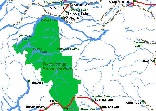
Tweedsmuir Provincial Park, the largest in British Columbia, covers an area of more than 981,000 hectares in the west-central region of the province, 480 kilometres by air northwest of Vancouver, BC. Roughly triangular in shape, the park is bounded on the north and northwest by the Ootsa-Whitesail Lakes reservoir, on the west and southwest by the Coast Mountains and on the east by the interior plateau.
Tweedsmuir Provincial Park was named for the 15th Governor General of Canada, John Buchan, Baron Tweedsmuir of Elsfield. The Governor General travelled extensively by float plane and horseback in the park in August of 1937, and he and his party were greatly impressed by its magnificence. "I have now travelled over most of Canada and have seen many wonderful things, but I have seen nothing more beautiful and more wonderful than the great park which British Columbia has done the great honour to call by my name."
| Services: |
| Bella Coola Grizzly Tours - The Bella Coola Valley is home to some of the worlds largest Grizzlies and Mountain Goats … and every Summer and Fall thousands of spawning Salmon return to the Bella Coola River. These spawning Salmon are a natural food source for the Grizzlies and other wildlife. We offer Grizzly Bear and Wildlife viewing, Eco Tours, Hiking Fishing, and more. |
| Bella Coola Valley Inn - Our three-and-one-half star hotel/motel, featuring beautifully appointed rooms, is situated in the beautiful Bella Coola Valley. Because we're close to the ferry, shopping, and attractions � a stay at the Bella Coola Valley Inn means you can mix comfort into your wilderness experience! Rental cars are available. |
| Brockton Place Guest House & Inn - Brockton Place offers luxury accommodations at affordable rates. Located 15 minutes from BC Ferries and 5 minutes from the airport, we cater to tourists and business travelers, offering something for everyone. Services include, tea and espresso bar/lounge, car rentals, backcountry excursions, river drifts, guided fishing arrangements, and much, much more |
| Escott Bay Resort - The adventure starts with fishing, hiking, horseback trail riding, pack trips and hunting � and with the snow comes x-country skiing & snowmobiling. Located between Tweedsmuir and Itcha Ilgachuz Parks, we offer fully serviced cabins and camping facilities. |
| Nature Trail Wilderness Lodge - Located on the edge of Tweedsmuir Park, on Tetachuck Lake, this is a unique fly-in lodge in BC's last true wilderness. Here you can explore, go canoeing, hiking, kayaking, fishing, wildlife watching, or just relax in your own cozy rustic lakefront cabin. Also � be sure to check out our Whitesail Wilderness Outpost |
| One Eye Outfit - Ride the mountains on a horseback tour & hike with experienced professional guides. This is a professionally outfitted authentic Western experience and we have over 20 years of service. Our fly-in holidays feature outpost camps, fishing, wildlife, solitude and serenity. |
| The Dean on Nimpo - The Dean on Nimpo, in the heart of the scenic Chilcotin, provides an excellent starting point for fishing, wilderness fly-in fishing, spectacular sight-seeing, hiking, snowmobiling and cross country skiing. Our resort has great gourmet meals � and Tweedsmuir Park, Itcha Ilgachuz Park, and the Charlotte Alplands are all within easy access. |
| Tweedsmuir Lodge - Abundant wildlife, rugged mountains, sparkling rivers pristine wilderness, our lodge is remotely situated on 50 acres, just steps from the Atnarko River, is nestled within Tweedsmuir Provincial Park, the largest protected park in British Columbia. |
 Alexander MacKenzie travelled through the area on his epic journey
to the Pacific Ocean in 1793. Alexander MacKenzie was the first white
man to view the western seas from the shores of northwest America, preceding
the more widely known Lewis and Clark expedition by more than 12 years.
Alexander MacKenzie and his party trekked
overland from the Fraser River, across the Interior Plateau, through
the Rainbow Mountains and down Burnt Bridge Creek, the present day western
boundary for part of the park. Where the creek enters the Bella Coola
River, they rested at a community which they dubbed "Friendly Village"
because of the hospitality of its native inhabitants, members of the Bella
Coola. From here MacKenzie and his men were transported down the river
by the Bella Coolas into Dean Channel. Hostile Bella Bella natives forced
them back before they reached the open sea.
Alexander MacKenzie travelled through the area on his epic journey
to the Pacific Ocean in 1793. Alexander MacKenzie was the first white
man to view the western seas from the shores of northwest America, preceding
the more widely known Lewis and Clark expedition by more than 12 years.
Alexander MacKenzie and his party trekked
overland from the Fraser River, across the Interior Plateau, through
the Rainbow Mountains and down Burnt Bridge Creek, the present day western
boundary for part of the park. Where the creek enters the Bella Coola
River, they rested at a community which they dubbed "Friendly Village"
because of the hospitality of its native inhabitants, members of the Bella
Coola. From here MacKenzie and his men were transported down the river
by the Bella Coolas into Dean Channel. Hostile Bella Bella natives forced
them back before they reached the open sea.
In his journal he wrote: "I now mixed up some vermillion in melted grease, and inscribed in large characters on the face of the rock on which we slept last night, this brief memorial: 'Alexander MacKenzie, from Canada, by land, the twenty-second of July, one thousand, seven hundred and ninety-three.' "
MacKenzie's rock, on the north shore of Dean Channel, is marked with a cairn and preserved in Sir Alexander MacKenzie Provincial Park.
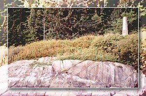 MacKenzie Rock with Commemorative Cairn |
Thousands of years before MacKenzie came to the area it was the home of the Bella Coola and Chilcotin Indians who depended on the abundance of salmon in the rivers for their livelihood. Today, decendants of these earliest inhabitants catch and process fish from the same rivers for their winter use in much the same way as did their ancestors.
The topography of the area is extremely varied. East of the park near Anahim Lake, the Interior Plateau abruptly gives way, at an elevation of about 1350 metres, to the peaks of the Rainbow Range. The range - Tsitsutl in the local dialect, meaning painted mountains - is an enormous dome of eroded lava and fragmented rock that presents to the viewer and astonishing spectrum of reds, oranges, yellows, and lavenders.
Contrasting with the vivid colouration and gentler slopes of the Rainbow Range are the higher and more rugged Coast Mountains that mark the western extremity of the park. Vast glaciers sculptured these granite giants, leaving behind serrated peaks still under the erosive attack of alpine ice. Tzeetsaytsul Paeks - so named by the Indians for the rumble and boom of its glacier - and its neighbour, Thunder Mountain, are dominant features of the parks west boundary. Monarch Mountain, 3533 m, at the southwest corner of the park, is the highest mountain in the area. Further evidence of the glacial activity of the past along the park's west side are the deep valleys of the Bella Coola and Atnarko Rivers and ocean fjords like Dean Channel.
The alpine and grass meadows north of Highway 20 are the habitat of grizzly and black bears, mountain goats, caribou and wolves and the summer range of moose and mule deer. In the more mountainous area south of the highway are goats, bears, mule and coastal blacktail deer, many smaller species and the occasional moose. South of the highway also, is the greatest variety of birdlife in the park including the magnificent trumpeter swans that winter in Lonesome Lake.
Lonesome Lake has become well known through the publication of books and stories about Ralph Edwards who settled at the lake not long after the turn of the century, many years before the park was created. The struggle of the Edwards family to wrest a homestead from this wilderness has made their story a classic of Canadian pioneering spirit.
![]()
MORE On Tweedsmuir Provincial Park
For
Information:
Alexander Mackenzie Trail Association,
P.O. Box 425, Stn. A, Kelowna, BC, V1Y 7P1
British Columbia Adventure Network © 1995 - Interactive Broadcasting Corporation