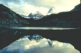
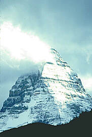
Noted for its spectacular hiking, Mount Assiniboine stands at 3,618
metres in this 38,600 hectare park bearing its name. The park is roughly
a triangular shape which borders partially on the boundaries of Banff
National Park and Kootenay National Park.
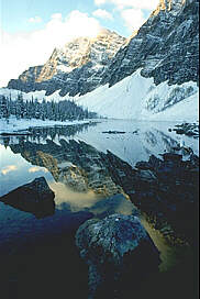
The jagged
peaks, shimmering lakes, glistening glaciers and sun- dappled alpine
meadows make this wilderness scenery some of the most stunning in the
Canadian Rockies. Vegetation consists of spruce, alpine fir, and lodgepole
pine as well as patches of false azalea, buffalo berries, twinberries
and white rhododendrons amongst many other spectacular species of flora.
Hundreds of species of wildflowers are found here during mid- summer.
Animals including the elk, black and grizzly bear, mule deer, moose,
mountain goats, squirrels and chipmunks, marten and mink and coyote
are found here as well as ninety-three species of birds.
Information & Services
If you would like to have your business listed, please Click Here.
LOCATION
Located
northeast of Radium Hot Springs and southwest of Banff is Mount Assiniboine
National Park. Routes to enter the park include Highway 93 to Lake Magog,
Spray Lake Resevoir to Lake Magog, Highway 93 to Lake Magog via the
Mitchell River and Sunshine Ski Valley to Lake Magog. Because of the
complicated nature of entering this park please contact either a local
map retailer or the address listed below:
BC Parks
District Manager
Box 118
Wasa, BC VOB 2K0
telephone (250) 422 4200
facsimile (250) 422 3326
PARK
FACILITIES & ACTIVITIES
Camping
- On the bench above the west side of Lake Magog is the main camping
area. A group camping area is provided. Camping is also located at the
north end of Og Lake. Water is provided by nearby springs and small
streams. Located on the south side of Magog Creek are four alpine cabin
shelters, known as the Naiset Cabins. A climbing shelter is located
in the Assiniboine Bowl and other cabins are found in various locations.
Campfires are not permitted throughout the core area of the park. Primus-type
stoves must be used for cooking.
Fishing
& Boating - Angling in the lakes and waterways of this park can
be rewarding but is unpredictable and often different lakes are closed
for fishing.
Hiking
& Trails - Numerous trails wind their way through the park. They
vary in difficulty and length, some being short, easy day hikes and
others long, difficult overnight trips. During the winter months, skiing
in and out of the park on either tele-mark skis or alpine touring equipment
is a popular way to see the area.
Other
activities - Horses are allowed in the park with a permit on specified
trails. Mountain bikes are allowed on the Assiniboine Pass Trail in
the park only.
COMMERCIAL
FACILITIES Near Lake Magog is the Mount Assiniboine Lodge.

 LOCATION
 Fishing
& Boating - Angling in the lakes and waterways of this park can
be rewarding but is unpredictable and often different lakes are closed
for fishing.
Fishing
& Boating - Angling in the lakes and waterways of this park can
be rewarding but is unpredictable and often different lakes are closed
for fishing.