| History
and Beauty: The Heritage Tours of the Kootenays |
Jan
Lee's Travellin' News
Photos courtesy of BC
Archives
|
|
|
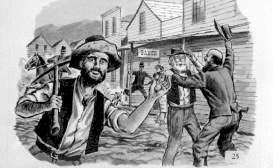
Rossland's
Gold Rush, �
1891. (it is a "painting,
drawing or print" according to BC Archives)
Photo by Robert John Banks.
|
A couple of years ago my family and I took a trip to the Kootenays.
I had just started my book on the history of a World War I historic
landmark called Shaughnessy Hospital on the other side of the province,
in Vancouver.
I was convinced its story epitomized the grandeur of British Columbia's
heritage. Yet I had read about places in the Kootenays that had worked
in concert with Shaughnessy to provide rehabilitation for Canada's returning
wounded. I was fascinated by these stories; I knew they exemplified
real heroism. Transporting the materials necessary to construct a medical
facility adequate to the needs of the returning veteran was one thing.
Caring for the veterans in these remote areas took dedication.
What I did not realize until I had visited the Kootenays, was that
these obstacles were a well known matter of history. Gold prospectors
had populated the area less than 50 years before. Places like Kaslo
and New
Denver were forged out of adversity and the optimism of a dream.
These communities knew a great deal about the price of sacrifice and
recovery. Although I did not have a chance to view the old convalescent
homes I had read about, I came away with an even better understanding
of BC's history - and the spectacular beauty of the Kootenays.

To reach the Kootenays, we took Highway 1 from Vancouver east to Hope,
then Highway 3 east to Grand Forks. Vancouver to Hope is 150 km/94 miles
and Hope to Grand Forks is 374 km/234 miles.
Continue on Highway 3 to Crescent Valley (120 km/75 miles). There you
will begin your journey through the fascinating countryside of the Silvery
Slocan Heritage Tour and the North Loop. The Silvery Slocan Tour is
an easy excursion through the most popular sections of this region.
The North Loop is fine for travellers who are comfortable driving narrow
gravel roads. If you are interested in really seeing Kootenay's back
country, the North Loop is a great way to begin. Come equipped with
dependable transportation and be prepared for breathtaking vistas.
|
|
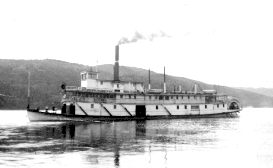
SS
Moyie on Kootenay Lake. � 1920
|
Nelson
(21 km/13 miles from Crescent Valley) is known for its dedication to
history. It has some 350 heritage sites dating back to the 1800s. Visitors
can tour Nelson by trolley car, or by self-guided walking tours. Located
on southwest shores of Kootenay
Lake at the base of the Selkirk
Mountains, Nelson offers a multitude of recreational opportunities.
Northeast of Nelson on Highway 3a, is Balfour,
one of my favourite little communities. Its arid mountain air on the
banks of Kootenay Lake was one of the reasons that wounded WWI veterans
were cared for there. I am sure the beauty of the area was rejuvenating
to the spirit as well. The Kootenay Lake ferry affords a great view
of the surrounding countryside.
|
|
|
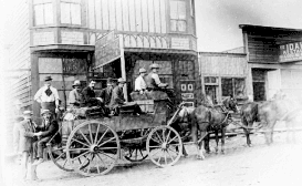
Kaslo
Stage to Sandon. �
1893
|
Highway 31 takes you north to Kaslo. (34 km/21 miles). Kaslo is known
for the SS Moyie National Historic Site, where the world's oldest intact
passenger sternwheeler stands as a testament to the booming communities
of the gold rush era. Many of the towns that sprouted north and west
of this town have since disappeared. Kaslo itself is a shadow of the
thriving community that once filled the west banks of Kootenay Lake.
A quiet, picturesque town, it offers a serene stop for travellers.
From Kaslo, you have a choice to either continue west on the Silvery
Slocan Tour, or to follow the North Loop. If your choice is to head
north, you are in for an adventure. It is 110 km/69 miles to Trout
Lake, the crest of the loop. The last 41 km/26 miles from Meadow
Lake is a good gravel road that is passable in warmer weather (not recommended
in ice or snow). Paved road resumes at Beaton, just north of Trout Lake.
Take a Photo Tour of Kaslo, Photos courtesy of Pennywise Paper
Kootenay Lake
Region | Buchanan Lookout
| Alpine-fed Lake | Kootenay
Lake
There are endless possibilities for hiking and wildlife viewing
in this area. The Macbeth Icefields, Horseshoe and Toby Glaciers
are popular with hiking enthusiasts. The Lake of the Hanging Glaciers
and Glacier Dome are on the other side of Jumbo Pass, a wonderland
of beauty and rugged wilderness. From ice and stone spires to the
remaining remnant of the Singing Forest, the Purcell Mountains are
one of BC's last vestiges of untouched wilderness. Bear, cougar
and moose can be seen (as well as Sasquatch, according to some researchers).
An entire article could be written on the beauty of the North Loop
and its glacier fed rivers and lakes. It is worth the excursion, especially
if you are equipped for the remote wilderness.
|
|
|
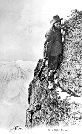
Prospector
Hiking to Gold Fields "In a Tight Corner"
� 1899.
Photo by Stanfield
|
At Galena Bay, the road becomes Highway 31. Nakusp, 49 km/31 miles
south, offers a dip in several refreshing hotsprings. The pools are
a popular year-round attraction.
At New Denver (47 km/29 miles), the south loop takes up again, at the
junction of Highways 23 and 31a (the connector from Kaslo). The town
is home to the Nikkei Internment Centre, a testament to the interned
Japanese-Canadians during World War II. The Silvery Slocan Museum is
worth visiting as well.
The stretch between New Denver (47 km/29 miles) and Kaslo has been
called the Valley of the Ghosts, after the many small communities that
thrived during the gold rush. It is a name that reflects determination
as much as the history of this region. In the deserted town of Sandon,
visitors can wander the streets and capture a sense of what it was like
for BC's pioneers.
Slocan, (32 km/20 miles) "BC's Shangri-La", is a fitting place to wind
up this tour of some of BC's most captivating hideaways. The Kootenay
region still remains one of BC's more remote wonderlands, and one of
its richest testaments to history and personal determination.
A note of thanks to Beth Weathers, Kaslo Information
Centre and Rachel Walmsley, Nakusp District and
Chamber of Commerce.
Special credit to Beth Weathers for assisting with the
research on the North Loop.
|
Information Contacts
|
Tourism BC
(general information)
800-661-6603
|
Nelson Chamber of Commerce
250-352-3433
|
Kaslo Information Centre
250-353-2525
|
|
Nakusp District & Chamber of Commerce
250-265-4234
|
� Copyright Jan Lee
Jan Lee jnlee@sfu.ca
Be sure to read other
articles by Jan Lee in the BC Adventure Network

|