Article & photos by Murphy Shewchuk
Go to
Helmcken... The mud didn't last. It soon turned to glare ice covered with just a enough snow to make it look pristine. Our destination for the day hike was Helmcken Falls. I was told it was one of the highest waterfalls in British Columbia and, because of the cold winter, the ice cone at the base would be spectacular. Our method of getting there was snowshoes.
After the usual fanfare that accompanies fifteen hikers, we set out, soon to discover that it snows a whole lot more in Wells Gray Provincial Park than it does in sagebrush-surrounded Kamloops. Dodging footprints set by a wallowing moose and frequently changing leaders, we trudged up the road. "Up" in this case, was not just a figure of speech. It seemed that at the crest of each hill, another loomed on the horizon. The light patter soon turned to heavy breathing. Those of us who were tagging along for the first time were heard to mutter "How much farther?" And the few who had been there before gave the pat answer, "Around the next corner." To spare my mind of the agony, suffice to say that we didn't make it to Helmcken Falls that day. We had a late lunch at Dawson Falls, explored the Mush Bowl and then, sore from snowshoeing through six kilometres of deep snow, we headed back to the waiting vehicles. As true masochists, we did not give up. Three weeks later, though fewer in number, we did make the 22 kilometre (14 mile) round trip to Helmcken Falls. Extinct
volcanoes... Wells Gray Park is an ideal vacation destination for the camper, hiker, backpacker or canoeist looking for wilderness. Whatever your interest, go mentally and physically prepared. For while there are fully-serviced campgrounds, motels and hotels in and near Clearwater, the BC Parks campgrounds in Wells Gray and Spahats Creek Parks are a little more rustic.
Stops
along the way... Just past Spahats, there is an access road to the Trophy Mountain alpine trails. The alpine meadows are spectacular in mid-summer. Farther along, the access road to Battle Mountain (km 26.9) leads right (east) 2.5 km to the head of another trail up to the alpine. Helmcken Falls Lodge, one kilometre before the main entrance to Wells Gray Provincial Park, (km 37) provides the last opportunity to stock up on supplies. Beyond this point, the amenities of civilization are limited. Green Mountain Road, a short side road just inside the park, provides access to a viewing tower on a mountain top. From this perspective, you can get an excellent overview of the area. A miniature
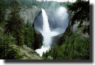
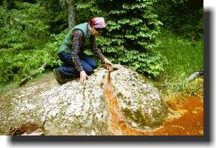
Niagara… Helmcken Falls, at 142 m (465 feet) is fourth highest in Canada and one of the most impressive in North America. At km 44, a four kilometre side road leads to the brink of the falls. Surveyor R.H. Lee discovered the falls in 1913 and suggested that it be named after then BC Premier Richard McBride. McBride insisted that they honor Dr. J.S. Helmcken who had come west as a Hudson's Bay Company employee in 1850 and stayed to become an active politician in the infant colony. The Ray Farm, at km 56.8, marks a long-abandoned homestead. John Bunyan Ray first came to the upper Clearwater in 1910 as a trapper. He married in 1932 and lived in the area until his death in 1947. Cold mineral springs bubble out of the ground near the farm buildings.
Bailey's Chute, a ten minute hike from the road at km 59.3, is one of the wildest rapids on the Clearwater River. During high water in early June, the roar of the chute can be heard a kilometre away. Clearwater
Lake… A strong word of caution: The outlet of Clearwater Lake is a waterfall that is not readily seen from the lake. Numerous boaters have died when they strayed too near the outlet and were swept over the falls and into the wild Clearwater River canyon.
The Clearwater Lake boat launch, (km 71.3) is the end of the road (well away from the outlet), but it need not be the end of your trip as a private company offers boat tours of Clearwater Lake during the summer months. Going
back…
Copyright © 1998-2009 Murphy O. Shewchuk www.murphyshewchuk.com Be sure to read other articles by Murphy Shewchuk in the BC Adventure Network |
![[Photo Copyright Murphy Shewchuk]](bchbrry.jpg)