Peace
River & Pine Pass Map
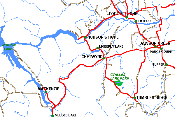
Fort
St. John, Tumbler Ridge, Dawson Creek, Mackenzie, Chetwynd & Hudson's Hope,
British Columbia
|
Plan
a Vacation
|
| Lodging
& Services: more
info |
| Accommodations |
Adventures |
Attractions |
| Events |
Dining
& Entertainment |
Shopping |
| Transportation |
Conference
Centers |
Publications
& Media |
|
| Recreation:
more
info |
| Attractions |
ATV
|
Boating |
| Camping |
Canoeing
& Kayaking |
Dog
Sledding |
| Fishing |
Golf |
Guest
Ranches |
| Health/Spas |
Cat
& Heli-Skiing |
Hiking |
| Houseboating |
Mountain
Biking |
Mountain
Climbing |
| Multisport |
Natural
Hot Springs |
River
Rafting |
| Skiing |
Snowmobiling |
|
 |
|
| Featured
Vacations:
View all
vacations |
|
|
|
|
Regional
Information
|
| Cities
& Towns Lodging, Hotels, Services
& Events . . more
info |
| Lakes
Resorts,
Cabins, Fishing Info, Maps . . more
info |
|
Travel
Info Travel
Journals,
Tourist
Info Centers, Weather,
Road
Conditions, BC
Ferries Info, Travel
Planner . .
more
info
|
| Points
of Interest . .
more info |
| Provincial
Parks
. . more
info |
| Trails
Hiking
& canoeing trails . . more
info |


Advertise
With Us
Promote
your business on the BC Adventure Network.
BC's largest and most visited tourism Web site . . . more
info.
Advertising
Inquiries:
advertising@ibcnetwork.com
©
1995 - 2018 Interactive Broadcasting Corporation
|