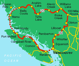
|
 DISCOVERY
COAST PASSAGE DISCOVERY
COAST PASSAGE
7 to 9 days
This
BC tour takes you from Vancouver
Island, up the coast by BC Ferries
to Bella
Coola and overland through some of
the more remote terrain of BC's Cariboo
Chilcotin region.
To
begin, take the ferry to Nanaimo
from Horseshoe
Bay and travel north on highway 19,
Vancouver Island's main connector. Your destination
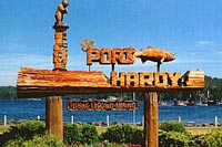
is Port
Hardy, Vancouver Island's northernmost
ferry terminal.
Situated
at the mouth of Queen Charlotte Strait, (391 km/245
miles north of Nanaimo), Port Hardy is the departure
point for the Prince
Rupert and Bella Coola Ferries. Plan
to stay over a night in Port Hardy before boarding.
Also remember to make a reservation for the ferry.
Bella
Coola, nestled amongst the fjords and
rivers of BC's Discovery Coast was a Hudson's Bay
outpost in the 1800's and home to many of the Bella
Coola Valley's indigenous peoples. Its museum provides
an interesting glance at northern BC history.
 |
|
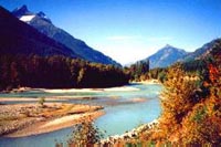
The
Bella Coola River Valley
|
Leaving
Bella Coola, follow
Highway 20 east.
Just east of Bella Coola is the settlement of Hagensborg
(approximately 20 km/13 miles from Bella Coola), settled
by Norwegian descendants in the 1890's.
Just
east of Hagensborg is a stretch of highway called
"The Hill", 43 km/27 miles of narrow road with steep
switchbacks and hairpin turns. "The Hill", winds up
into Tweedsmuir
Park, with its magnificent Tsitsutl
Range. The spectrum of orange, yellows, purples and
reds make this collection of lava and fragmented rock
a unique sight.
Upon ascending "The Hill", Hwy. 20 is dotted
with many small communities offering a variety of
services:
Anahim Lake and
nearby
Nimpo Lake,
Tatla Lake (235
km/197 miles from Bella Coola), and
Alexis Creek,
(approx. 109 km/68 miles east of Tatla Lake). Attractions
in the area include
fishing,
camping,
horseback riding, rodeos and wintertime cross country
skiing.
 |
|
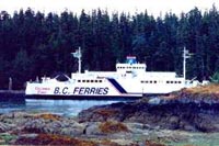
The
Discovery Coast Ferry
|
Several
provincial parks are accessible by secondary roads.
4 wheel drive is necessary for some back roads.
Williams
Lake (112 km/70 miles east from Alexis
Creek) is your last destination on Highway 20, as
you turn south onto Highway 97. The city is rich in
history, and the home of the Williams Lake Stampede,
one of BC's largest rodeos, held in the week of July
1st each year. Visit the Museum of the Cariboo Chilcotin
to learn about the heritage of this area.
Leaving
Williams Lake, follow Highway 97 as it guides you
through the famed "Gold Rush Trail", the historic
route of trappers, miners and gold seekers and the
breathtaking beauty of the Fraser Canyon. The town
of Clinton
(163 km/102 miles from Williams Lake) is known
as the "Guest
Ranch Capital of North America". Marble
Range Provincial Park, west of Clinton, offers stunning
scenery. It is also a favourite among ice climbers,
many of whom flock to the area each year.
South
of Clinton, and just before reaching Cache Creek,
your route turns west onto
Highway 99 -
the road past Pavilion Lake and on to Lillooet. Marble
Canyon Provincial Park offers camping on the southeast
end of Pavilion Lake.
Lillooet,
"Mile 0" during the gold rush (104 km/65 miles from
Clinton), possesses an excellent gold rush museum.
 |
|
Port
Hardy
|
Beautiful
scenery and outstanding nature viewing await you as
you wind through the mountains on the way to the town
of Pemberton and beyond to the world famous ski resorts
of Whistler. Camp in any number of BC Forest Service
sites on the way and enjoy the bounty of fishing opportunities.
Whistler
(32 km/20 miles from Pemberton) needs little introduction
to skiers. The resort offers numerous summer activities
as well, from street festivals to fine dining.
Don't
forget to visit
Garibaldi Provincial Park,
known for its beauty and unspoiled forests, as you
wind your way south of Whistler. As you travel the
Sea to Sky Highway
from Whistler to Squamish
(60 km/37 miles from Whistler) and along the coast
to
West Vancouver,
the scenery is a treat you will not want to miss
capturing on film. There are a number of roadside
stops on the west side of the road, but be mindful
of the traffic.
From
West Vancouver take the Lions Gate Bridge to return
to
Vancouver.
Be
sure to browse the Points of Interest:
Read
a Travelog:
Check
BC Ferries Information
|