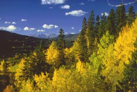
| Northern
BC's Peace River Valley |
|
|
|
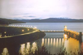
W.A.C.
Bennett Dam
|
|
Photo
courtesy of Northern BC Tourism
|
Like
much of Northwestern Canada, BC's Peace River country owes its early
notoriety to fur traders, gold seekers and several thousand World
War II soldiers. History books describe the creation of the Alaska
Highway as one of man's greatest feats of human determination and
ingenuity. Its construction by the military in 1942 not only opened
commerce to the communities of Canada's far north, but encouraged
hardy travellers to seek out new opportunities at the foot of the
Alaska Highway, in the rugged outback of the Peace River Valley.
These
days, travelling to Northern BC does not require the grit and ingenuity
of olden days. The roads are paved, there are roadside restaurants
that serve hot meals, and mechanics where there once were none. RV'ers
will find an increasing number of campgrounds with electrical hookups
and other specialized amenities. Campers can choose from as many as
20 camping areas - not counting those enticing wayside stops that
make "roughing it" a preferred way of travel.
Travellers
should keep in mind that while the "remoteness" of Northern BC is
inviting, it also demands an extra amount of pre- planning. Come prepared
for those long stretches of road without amenities. Check your gas
and know your vehicle. Subscribe an emergency roadside service and
if possible, carry a cell phone or alternative communications system.
These
are common-sense practices that are useful in any travel situation
and will make your vacations in BC's northern areas more comfortable
and "stress-free".

|
|
|
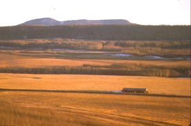
Chetwynd
countryside
|
|
Photo
courtesy of Wayne Sawchuk
|
The
Peace River area offers its own mini "circle tour" that is accessible
from Prince
George. The route takes you through some of the provinces more
pristine countryside, past towns that were forged with the introduction
of the Alaska Highway and through numerous fishing and camping areas.
It is an easy route for short jaunts to nearby attractions. Travellers
carrying on to the Yukon or Alaska can also connect with the Alaska
Highway from this route.
Situated
786 km/487 miles from Vancouver
at the intersection of Highway 97 (the Alaska Highway) and Highway
16 (the Yellowhead Highway), Prince George is accessible by any number
of directions and modes of travel. If you are coming from Vancouver,
you can pick up Highway 97 in the small town of Cache
Creek, the intersection to Highway 1 (the TransCanada, which you
can join in Vancouver) and Highway 97. You can also reach Prince George
from the Alberta-British Columbia border via the Highway 16. If you
plan to take BC Ferries Inside Passage to Prince Rupert, you can reach
Prince George by rail, plane or by car via Highway 16.
|
|
|
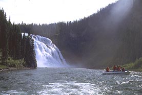
Tumbler
Ridge, BC
|
|
Photo
courtesy of Photographic Options
|
Highway
97 north from Prince George to Mackenzie takes you past several provincial
parks and a tempting number of good fishing areas. Forest Service
recreation sites dot the Crooked River area, a bastion for char, rainbow
trout, arctic
grayling and other species of fish. Summit
Lake, Bear Lake and Hart
Lake are within easy distance from the Crooked
River Provincial Park, 70 km/43 miles north of Prince George.
The
town of Mackenzie
(190 km/118 miles north of Prince George) can be reached by taking
Highway 97 north to the turnoff for Highway 39, a short distance from
Mackenzie. Northwest of Mackenzie is Williston Lake and the villages
of Germansen Landing and Manson Creek. Self-equipped travellers will
find an unlimited number of gravel roads and camping areas to explore.
Chetwynd
is at the crossroads of Highways 97 and 29, 310km/193 miles northeast
of Prince George. The road takes you over Pine Pass and presents you
with spectacular views of the Rocky Mountains and Azouetta Lake. Chetwynd
has a municipal campground with 15 basic sites, a tennis court and
a sani-station.
|
|
|
Tumbler
Ridge, BC
|
|
Photo
courtesy of Northern BC Tourism
|
Highway
29 south from Chetwynd leads you to the community of Tumbler
Ridge 105 km/65 miles). Established less than 20 years ago, it
services the coal mining industry in the Rocky Mountains. The trails
around Monkman Provincial Park (60 km/37 miles south by gravel road)
provide off-road enjoyment for snowmobilers and skiers in the winter
and mountain bikers and hikers in the summer. Kiuseo Falls are a well-known
attraction at Monkman.
| BC
Adventure Members serving this area: |
| Monkman
Expeditions - Join us for world-class hiking, canoeing,
and river boating adventure expeditions in the Monkman Pass region
of BC's Peace River. You'll experience the untouched wilderness
of the Rocky Mountains in Monkman Provincial Park and area --
a place like no other. |
64
km/40 miles north of Chetwynd on Highway 29, is Hudson's Hope and
the site of the W.A.C. Bennett Dam, one of the largest hydro systems
of its kind in North America. The museum in Hudson's
Hope features fossils that date back more than 11 thousand years
and give evidence to why this area is commonly called "the land of
dinosaurs and dams."
|
|
|
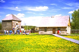
Fort
St. James National Historic Site.
|
|
Photo
courtesy of Northern BC Tourism
|
Fort
St. John (88 km/55 miles) was established in 1794 as a trading
post, when its population consisted of 12 men, 4 women and 5 children.
Now the largest city on BC's Alaska Highway, it is a golf course
mecca of the Peace River Valley.
At
Fort St. John, your route returns to Highway 97, turning south to
Dawson Creek
(75 km/47 miles). This farming area is known for its honey and produce,
which is featured at the town's farmer's market each Saturday, May
through September.
Dawson
Creek (not to be confused with Dawson City) is also known as "Mile
O" of the Alaska Highway. World War II had a decisive effect on this
town, whose population grew from 600 to 10,000 in 1942. A visit to
the "Mile 0" cairn is a must as is a walking tour of the town's unusual
museums and heritage sites.
Travellers
will also enjoy several attractions in the area, including the Gold
Panning Championship in August, near Taylor. The Dawson Creek Stampede,
also in August, is legendary, as is its World Class Chuckwagon Racing.
Contact one of the information centres listed below for further information.
From
Dawson Creek travellers have a number of routes to choose from. You
can complete your loop back to Prince George via Highway 97, or head
to Tumbler Ridge via Highway 29. Or you can carry on to Alberta's
famed Jasper National Park, the subject of next month's article.
See
you then!